
Chitta Katha Lake trek
Chitta Katha Lake trek
Chitta Katha Lake trek
About
The Chitta Katha Lake trek is a challenging expedition located in the Neelum District of Azad Jammu & Kashmir, specifically within the Shounter Valley at an elevation of 4115m (approximately). This point-to-point trail spans approximately 14km and offers dramatic mountain vistas throughout its demanding duration. The journey begins via a rugged jeep track from Kel to Domail Bala, marking the start of an intense hike that can last anywhere between 6 to 8 hours due to difficult terrain underfoot.
Frequently Asked Questions
When is the best time to visit Chitta Katha Lake trek?
The best time to visit is during July, August and September. These months offer the most favorable conditions for visitors.
What is the elevation of Chitta Katha Lake trek?
Chitta Katha Lake trek is located at an elevation of approximately 4,115 meters (4.1 km) above sea level.
How difficult is the trek to Chitta Katha Lake trek?
The difficulty level of Chitta Katha Lake trek is rated as Hard — requires excellent fitness, prior trekking experience, and proper gear.
Do I need a guide for Chitta Katha Lake trek?
Yes, a guide is recommended for Chitta Katha Lake trek. Hiring a local guide enhances safety and provides valuable insights about the area.
Is Chitta Katha Lake trek family-friendly?
Chitta Katha Lake trek may not be suitable for young children due to terrain or conditions. Consider the difficulty before bringing family.
How long does it take to explore Chitta Katha Lake trek?
It takes approximately 8 hours to explore Chitta Katha Lake trek. Plan accordingly.
How long is the trail at Chitta Katha Lake trek?
The trail at Chitta Katha Lake trek is approximately 14 km long.
What type of trail is Chitta Katha Lake trek?
The trail at Chitta Katha Lake trek is a point-to-point route.
What is the elevation gain at Chitta Katha Lake trek?
The total elevation gain is approximately 1,524 meters.
Is it safe to trek to Chitta Katha Lake independently?
The trail is quite demanding and can be confusing in the upper reaches, so hiring a local guide from Shounter Valley is strongly advised. Additionally, the area's remote nature makes solo trekking risky in case of injury.
What are the camping options near the lake?
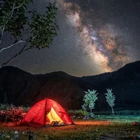
Most trekkers camp at 'Dak 2' or 'Dak 1' before the final ascent, as camping directly at the lake shore can be extremely cold and windy. You must bring your own high-altitude camping equipment and fuel for cooking.
Is there mobile signal at Chitta Katha Lake?
There is absolutely no mobile network coverage once you leave the main Neelum Valley road. You should expect to be completely offline for the duration of the trek from Shounter onward.
How should I manage water requirements on this trail?
Abundant glacial meltwater streams are available along the route, but the water is ice-cold and should be filtered. Carrying a reusable bottle with a built-in filter is the most practical solution.
Are porters and mules available for the lake trek?
Mules and porters can be hired at the Shounter Valley trailhead to carry heavy bags and camping kits. This is a common practice to save energy for the steep final climb to 13,500 feet.
Weather
Location
You might also like…
Similar attractions in Neelum
Reviews
No reviews yet. Be the first to share your experience!