
Bedori Top
Bedori Top
Bedori Top
About
Bedori Top is a challenging yet worthwhile trek located in the Haveli District of Azad Jammu & Kashmir at an elevation of 3,727 meters (12,228 feet). The journey to this peak takes approximately five hours and requires moderate difficulty levels due to its steep terrain. The best time for trekking Bedori Top is during the summer months from July through September when lush green landscapes provide a scenic backdrop against which you can marvel at large views of the massive Pir Panjal mountain range in Indian-administered Kashmir and surrounding valleys below.
Frequently Asked Questions
When is the best time to visit Bedori Top?
The best time to visit is during July, August and September. These months offer the most favorable conditions for visitors.
How do I get to Bedori Top?
Bedori Top requires hiking or trekking to reach. No road access is available.
What should I know before visiting Bedori Top?
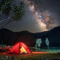
This is one of the highest peaks in the Haveli district. The trek is demanding and requires good physical fitness and proper camping gear as there are no guest houses at the top.
Is it safe to camp overnight at Bedori Top?
Camping is common for trekkers, but it is essential to go in a group and carry high-quality cold-weather gear due to sudden temperature drops and strong winds.
Are there any shops or facilities at the summit?
There are no shops, toilets, or facilities at the top; travelers must carry all necessary water, food, and emergency medical supplies from Haveli or Forward Kahuta.
What is the elevation of Bedori Top?
Bedori Top is located at an elevation of approximately 3,727 meters (3.7 km) above sea level.
What unique views can I expect from the peak?
From the summit, you can get a panoramic 360-degree view of the Pir Panjal Range and, on very clear days, glimpses of distant peaks like Nanga Parbat.
How difficult is the trek to Bedori Top?
The difficulty level of Bedori Top is rated as Moderate — requires reasonable fitness and some hiking experience.
Is mobile network coverage available at the top?
Mobile signals are extremely weak or non-existent at the peak, so it is important to inform someone of your schedule before starting the ascent.
Do I need a guide for Bedori Top?
Yes, a guide is recommended for Bedori Top. Hiring a local guide enhances safety and provides valuable insights about the area.
Is Bedori Top family-friendly?
Bedori Top may not be suitable for young children due to terrain or conditions. Consider the difficulty before bringing family.
How long does it take to explore Bedori Top?
It takes approximately 5 hours to explore Bedori Top. Plan accordingly.
Are any special permits required to hike Bedori Top?
Pakistani citizens generally only need to carry their original CNIC for verification at local security checkpoints. However, due to its proximity to the Line of Control, foreign tourists may require a specialized No Objection Certificate (NOC) from the Ministry of Interior.
What kind of base camp facilities are available near the peak?
There are no permanent base camp facilities at the summit; hikers usually set up temporary camps at the lush meadows located just below the final ridge. Most visitors use the town of Forward Kahuta or nearby villages as a launching point for logistics and supplies.
What type of trail is Bedori Top?
The trail at Bedori Top is a point-to-point route.
When is the most stable weather window for an expedition?
The most reliable weather window occurs from late June to early September when the snow has mostly melted and the trails are clear. Clearer skies are typically found in the early mornings, as afternoon clouds and localized rain are common in the monsoon season.
What is the elevation gain at Bedori Top?
The total elevation gain is approximately 1,996 meters.
What is the elevation gain at Bedori Top?
The total elevation gain is approximately 1,996 meters.
Are there formal rescue services available on the mountain?
There are no dedicated civilian mountain rescue teams stationed at Bedori Top. In emergencies, travelers must rely on local residents or coordinate with nearby military outposts for assistance, making it essential to carry a comprehensive first-aid kit.
Are porters available for the climb to Bedori Top?
Porters can be hired from the nearby villages in Haveli to help carry camping gear and supplies. It is recommended to arrange this through a local contact before arriving at the trailhead.
What is the expected fitness level for reaching Bedori Top?
A high level of cardiovascular fitness and endurance is required due to the steep incline and the thin air at altitudes exceeding 12,000 feet.
Is it safe to trek to Bedori Top without a local guide?
Due to its proximity to the Line of Control and the lack of defined trails in certain sections, trekking with a local guide is highly recommended for safety and navigation. Always keep your original CNIC or passport with you for security checkpoints.
Are trail markers present on the route to the peak?
There are no official signs or markers; the route consists of rocky ridges and shepherd paths, so navigating by landmarks or local knowledge is necessary.
What wildlife might I encounter near Bedori Top?
The area is home to various bird species and occasionally Himalayan wildlife like marmots, so trekkers should keep a respectful distance from any animals spotted.
Is there drinking water available on the higher reaches of the mountain?
Reliable water sources are scarce near the summit. You should fill up your containers at the lower alpine streams before beginning the final push to the top.
Weather
Location
You might also like…
Similar attractions in Haveli
Reviews
No reviews yet. Be the first to share your experience!